
FDI Creative Services, Inc.
Our Story
Our Story
Through the early years, the small team at Zupt was unsatisfied with the environmental impact and time consumed for conventional land survey techniques used for onshore seismic data acquisition. They first introduced an inertial navigation instrument that was carried by two people (A-PINS). This solved the environmental impact and efficiency issue but created a health and safety issue. Two people carrying the same piece of equipment up and down the side of mountains and through swamps was not practical. This led to the introduction of the backpack portable INS (B-PINS) that has seen success around the world and has surveyed many tens of thousands of Kms.
The team then took their focus to the subsea metrology operations where precise measurements are made between two structures in up to 4,000m water depth. This was also a development focused on efficiency and saving many hours of vessel time consumed to complete metrology surveys – saving both time and the carbon footprint for these operations.
The strong focused engineering and operations team at Zupt continues to revolutionize the way that various measurements and repetitive operations are completed. Zupt remains a small business focusing on helping people make what is complex simple, Zupt continues to find better and newer ways to do things where others do not try.
Applying our knowledge in other Industries: Zupt Autonomous Products and Technologies (ZAPT)
FAQ
Q: How big is Zupt?
A: With a core staff of 18 people, we supplement our offshore services team with contractors who have been working with us for years. We conduct training courses for our core services to ensure properly certified contractors are available when work gets busy and we need to expand past our core staff.
Q: Do you sell products or services?
A: Both! We provide offshore services with personnel and equipment to perform a variety of offshore marine construction survey projects. Also, we have offshore products we exclusively sell, such as a Fusion Splice and MicroTTU. Some of the sensors used for our service provisions are not for direct sale. They are used only by Zupt trained staff to provide data deliverables to the end client, such as jumper metrology deliverables after conducting a metrology using our C-PINS inertial navigation system.
Q: Where do you work?
A: Zupt works worldwide! We have local content partners worldwide with a heavy presence in West Africa and the UK. We have performed marine construction survey work in the Gulf of Mexico, the North Sea, West Africa (Ghana, Congo, Nigeria, Angola), Australia, South America, and the Bahamas. We work off of survey vessels, platforms, or rigs.
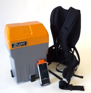
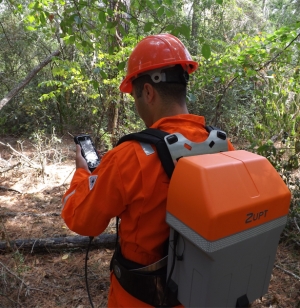
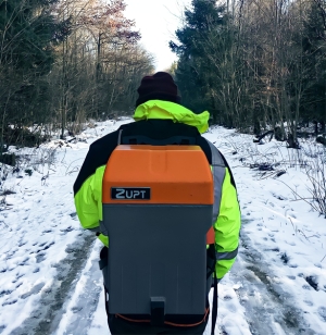
B-PINS V2
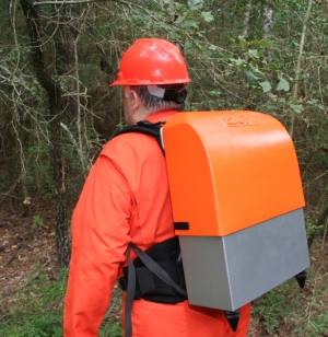
B-PINS is a precise survey tool designed to provide accurate navigation in GNSS denied areas with four times the productivity of traditional survey methods. B-PINS employs proven inertial navigation technology to provide a portable and accurate survey solution under dense canopy or urban canyon situations. The high-performance inertial sensors integrated into B-PINS deliver proven positioning accuracy significantly better than survey tolerances accepted by the international seismic acquisition community.
Product Specs
- Over 10 hours operations on a single battery set
- Continuous operations with hot swap battery
- Complete System weight ~17 kg (38 lbs)
- Job file preplot data configured for use in GPSeismic®
- Post processed survey data configured for GPSeismic®
- Operating Temperature -3°C to 55°C
- Storage Temperature -20°C to 90°C
B-PINS X
B-PINS X is the newest inertial survey tool for land operations. The B-PINS X employs the same proven inertial navigation technology as the existing B-PINS system to provide a portable and accurate survey solution in GNSS denied areas. B-PINS X improves upon the existing B-PINS system design with reduced weight and size, longer-lasting batteries, a wireless handheld data collector, and a laser range finder. B-B-PINS X has been designed to extend survey time and increase surveyor productivity.
Product Specs
- Over 16 hours operations on a single charge
- Continuous operations with hot swap battery
- Complete System weight ~14 kg (30 lbs)
- Job file configuration through GPSeismic®*
- Operating Temperature -3°C to 55°C
Underground/Mine

In areas with absolutely no access to GNSS signals, B-PINS is an ideal survey tool to accurately map or navigate through underground areas. B-PINS can be carried by surveyor/vehicle deep into underground mines to survey and plot a path in real-world 3D coordinates.
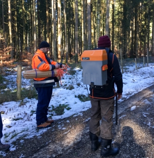
Forestry Mapping
Surveys completed with the B-PINS system enable surveys to be completed in environmentally sensitive areas such as in dense forests. Because our method does not require a clear line of sight through the woods, it poses a minimal threat to trees and vegetation. The B-PINS system provides accuracy, high levels of survey productivity, with very low to no environmental impact.
Pipeline Right of Way
Zupt’s B-PINS deliver precise stakeout locations in harsh environments during pipeline right of way where conventional survey methods are inefficient or ineffective. Field testing by pipeline stakeout professionals determined B-PINS is the choice for getting the job done accurately and productively at the lowest cost. A surveyor simply calibrates the B-PINS, walks the pre-determined pipeline route, processes, and adjusts the data, and imports it into a modeling package for precise horizontal and vertical coordinates of the terrain.
Seismic Stakeout
Zupt’s inertial solution, B-PINS, allows survey operations with minimal cutting while significantly increasing the production of field survey crews. During land seismic exploration, tree canopy often permits GNSS use for precise placement of survey stakes. Signals from the satellite segment of GNSS systems cannot penetrate through the tree canopy. Optical survey techniques can be used when the tree canopy or terrain limits GNSS operations, but it requires extensive cutting for a clear line of sight to operate. This cutting takes a significant amount of time and can have detrimental effects on the environment in the surveyed areas. One inertial survey crew using B-PINS can deliver the production of several conventional crews with post-survey processing results equal or better than GNSS surveys.
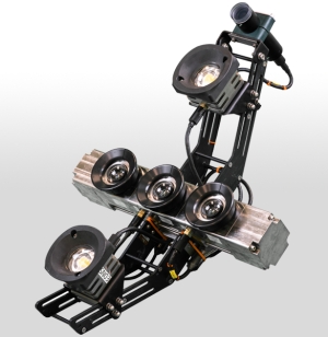
HaloCAM
HaloCAM is a subsea imaging sensor that monitors the verticality, heading, and relative position of any structure that has an April Tag adhered to it. Derived from the Halo INS, HaloCAM combines a high-definition machine vision camera with a navigation grade INS. HaloCAM mobilizes to the ROV with no dimensional control required for fixed offsets from the camera to an external INS.
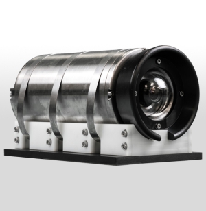
3D Recon
3D Recon is a standalone 3D modeling sensor that delivers real-time sparse point clouds that double as a relative-to-structure navigation system and a quality control metric to ensure complete coverage of what is seen subsea. 3D Recon incorporates three machine vision cameras with a MEMS IMU rated to 4000 meters of water depth. The final output from 3D Recon is a near real-time high-density 3D model (point cloud or mesh). Initially developed for Integrity Management and Inspection, and Repair and Maintenance purposes, 3D Recon also has applications for mooring chain link inspection, hull inspection, jumper/spool metrology, pipeline Out-Of-Straightness surveys, pre-install/as-built, and many more subsea applications.
Product Specs
- Type of Application – Marine
- Year of Introduction – 2020
- Length - 77.9 cm
- Width - 59.4 cm
- Depth - 30.0 cm
- Weight in Air - 34Kg
- Weight in Water - 23Kg
- Power Requirement - 24VDC 6A / 150W
- Serial Communications - RS232 (230400 bps)
- Housing – Titanium
- Rated - 4,000 m
- Number of Cameras – 3
- Sensor Type - Active Pixel CMOS, Global Shutter Resolution - 2028 x 2448
- FoV Horizontal - 85°
- FoV Vertical - 65°
- Number of Frames Per Second - 5 - 10 fps Copper & 10 - 20 fps SM Fiber
- Start Up Time - 0.02 s
- Communication - 1 Gbps Ethernet Copper & 10 Gps
- SM Fiber - Single Fiber Channel
- Software – Included
- Export Image Formats - Color palletized Mesh, Point Cloud *.ply (Binary)
- Battery Type - No Battery
Asset Identification
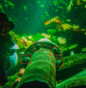
Zupt’s asset identification solutions are trained to identify certain object in practical subsea scenarios. Zupt develops and deploys software solutions that utilize Tensorflow and Yolov4 for object identification. Remove additional personnel offshore by introducing artificial intelligence packages to detect and identify assets automatically available as either topside units that utilize existing ROV cameras or complete sensor packages.